Mardi Gras parades in New Orleans (NOLA) have been running since the late 1830s. At first it was just a regular parade (for the time period), with street processions of maskers with carriages and horseback riders. “Throws” began sometime around 1870, which were followed a few years later with floats. Industry and technology have improved every aspect of Mardi Gras every since, but this year NOLA’s City Hall has released something that will make attending Mardi Gras a whole lot easier for revelers.
But first a little more background, especially for those who have never been to NOLA and/or NOLA during Mardi Gras season before.
Mardi Gras is actually an entire season that lasts several weeks. It begins on King’s Day (a.k.a. Little Christmas, Three Kings Day, Twelfth Night and/or the Epiphany) on January 6th and continues straight through until Fat Tuesday (the day before Ash Wednesday), with daily/nightly themed balls and parades. Mardi Gras itself is technically only the events held on Fat Tuesday; the entire time frame is often known as Carnival Season, but over the years the several weeks it’s taken up have commonly been known as Mardi Gras (especially outside of NOLA).

If you’re a tourist during Carnival Season and have plans to take part in some parades, you have to do a lot of planning, and the info for them may not be super easy to find if you don’t know where to look – but this year, NOLA’s City Hall’s got you covered and I think this is brilliant.
routewise.nola.gov is a brand new website offered by The City Of New Orleans that lets you know all about Mardi Gras events – what parades will be running, the date and time they’ll be running, their routes, where food vendors, First Aid and Lost Child stations can be found on the route(s), and the all-important “Where are the bathrooms?!?!?!”
Here are some examples of what you can see from the page (click on the photos for better views):


Oh, and the maps for each event do zoom in and out so you can see street names.
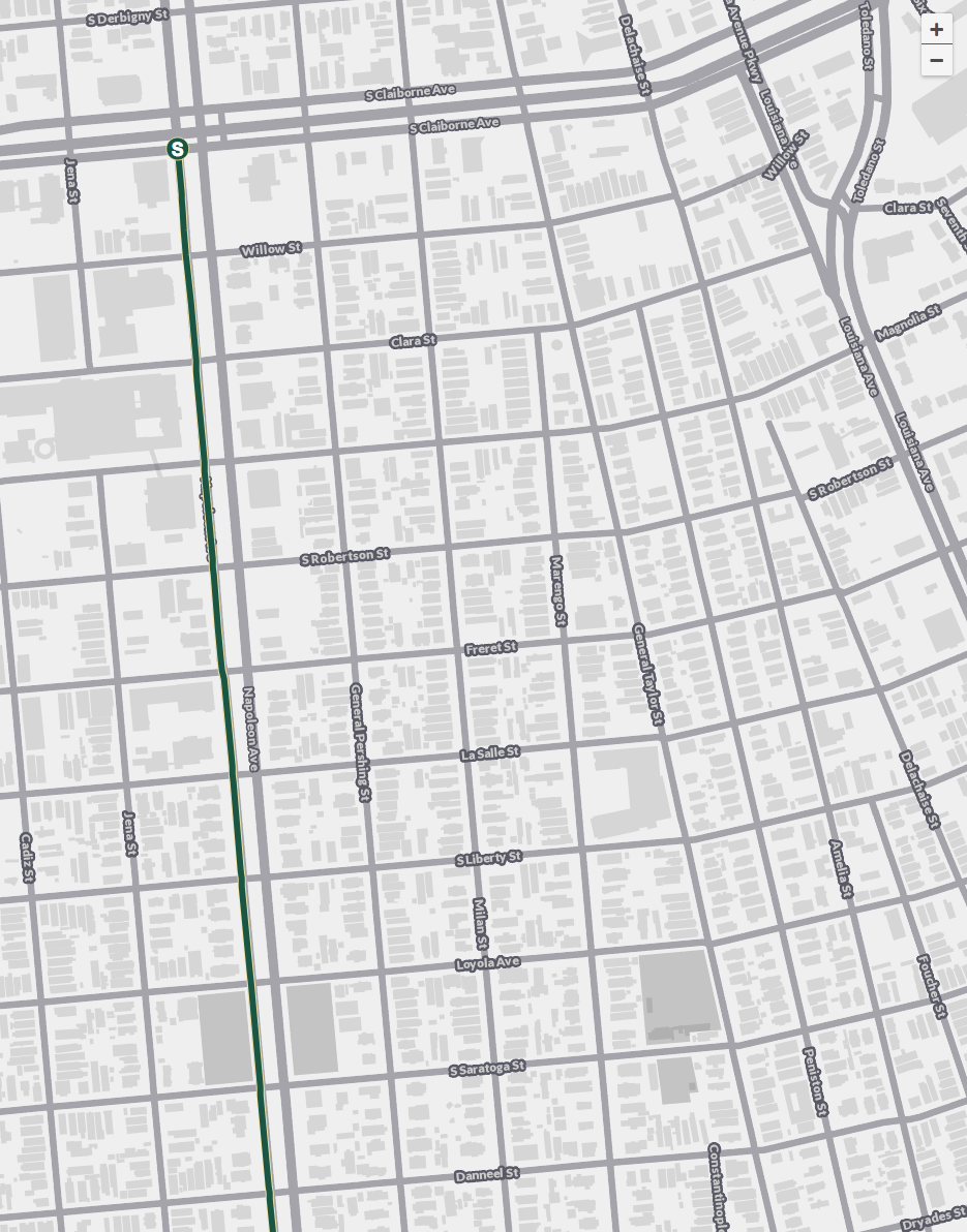
Start of Crescent City parade route, with zoomed in map
Routewise isn’t an app (yet) but the website is mobile-friendly. Here’s a photo from www.nola.com with how to download the page as a bookmarked link:
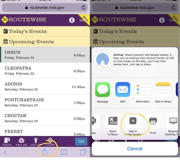
From www.nola.com: “Here’s how to download the parade tracker as a bookmarked link so it will appear as an app on an iPhone screen. First, click on the center icon at the bottom of the screen with the square-arrow, which will bring up a screen of options. Second, click ‘add to home screen’ for the website to add an icon to your home screen.”
Once Mardi Gras is done, information on second-line parade routes (like the one we had) will also be available on Routewise.
The city is apparently looking into turning Routewise into a full-fledged app for this year. It seems like a handy little tool, and I wish them the best of luck!
Like this post? Please share it! We have plenty more just like it and would love if you decided to hang around and clicked the button on the top (if you’re on your computer) or the bottom (if you’re on your phone/tablet) of this page to follow our blog and get emailed notifications of when we post (it’s usually just two or three times a day). Or maybe you’d like to join our Facebook group, where we talk and ask questions about travel (including Disney parks), creative ways to earn frequent flyer miles and hotel points, how to save money on or for your trips, get access to travel articles you may not see otherwise, etc. Whether you’ve read our posts before or this is the first time you’re stopping by, we’re really glad you’re here and hope you come back to visit again!
This post first appeared on Your Mileage May Vary
